Fuzzy logic model in landslide hazard zonation based on expert judgment

Geophysics

Authors

  • R. Sharifi Department of Geology, Science and Research branch, Islamic Azad University, Tehran, Iran
  • A. Uromeihy Department of Geology, TarbiatModares University, Tehran, Iran
  • M. Ghorashi Department of Seismotectonic, Geology Organization, Tehran, Iran

DOI:

https://doi.org/10.14331/ijfps.2011.330023

Keywords:

Fuzzy logic method, Landslide, Landslide Hazard Zonation, watershed management, Karaj, Iran

Abstract

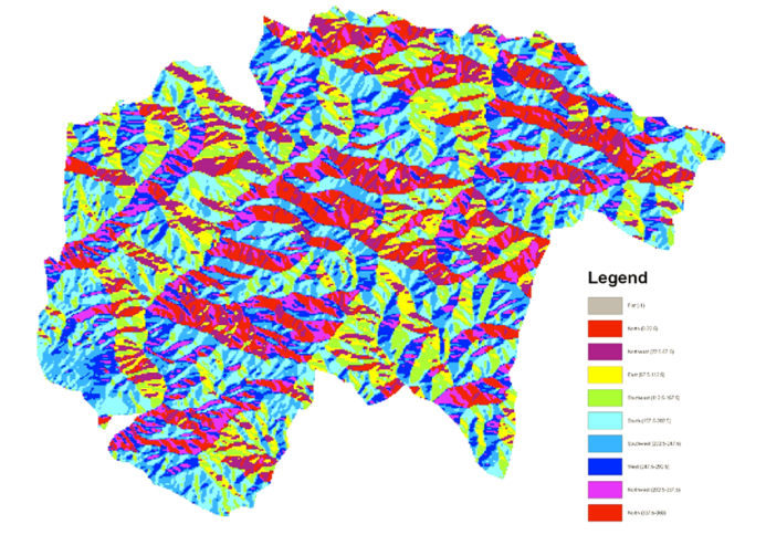
In this research landslide, hazard zonation provided based on fuzzy logic method and investigating of this model is efficiency. In the first provided the geology of slope and aspect maps by using aerial photos topography maps and field operations in watershed management of Karaj. Then, these maps classes of priority and coming next determine based on
existing landslides area in the geology, slope and aspect of maps in GIS software. In the geology map of Karaj formation (contain shale, tuff, marl, sandstone and conglomerate) and Tizkuh formation (contain limestone) and in the slope map of percent 25≤ S< 45 and 0≤ S <15 classes and in the aspect map south and east classes sequential have most and least landslide area. Then, in final drawer to dimension centimeters 2 in region watershed of map and we counted from 0 until 153 based on geology, slope and aspect. Then (y) units settled sequential, numbers 0 to 27 in very low sensitivity class (one class), numbers 28 to 66 in low sensitivity class (two class), numbers 67 to 89 in middle sensitivity class (three class), numbers 90 to 126 in high sensitivity class (four class) and numbers 127 to 153 in very high sensitivity class (class five). Based on these classes, provided the landslide hazard zonation founded on fuzzy logic method. Comparison fuzzy map and surface distribution landslide showed about percent 2.19 ( 140.53 hectare), percent 5.08 (325.98 hectare), percent 18.79 (1205.75 hectare), percent 43.38 (2783.70 hectare) and percent 30.56 (1961.04 hectare) sequential settled in one, two, three, four and five classes which are acceptable results to recommend it to prevention of the probable risks and damages is suggested, innovation and spreading of road construction in area is on basic of limitations of the landslide risk breadth plan.

Downloads

Download data is not yet available.

Author Biography

M. Ghorashi, Department of Seismotectonic, Geology Organization, Tehran, Iran


REFERENCES

1.Kalarestaghi A., Investigation of Effective Factors on Landslide Occurrence and Landslide Hazard Zonation –Case study Shirin Drainage Basin,Sari,Iran(2003).

2.MuthukumarM.,lineament Controlled Landslide of NilgiriMountains,India-A Geospatial Analysis,Journal of Diaster Advances,Vol4(3),15-19(2011).

3.Alexander, D., On the Causes of Landslides: Human Activities, Environ GeoL water sci, Vol 20, No.3. 165-179,(1992).

4.Berbarian, M., Talebian. M., Research and Study New Tectonic and Seismotectonic from Point of the Earthquake Fault in Semnan, Country Geology Organization,Iran, 63,(1996).

5.Elfon, D.J., Juang, C. H.,Asphalf Pavement Evaluation Using Fuzzy Sets, Transportalion Research Record: 1196, (1998).

6.Ding Mingatao and Wei Fangqiang .,Distribution Characteristics of Debris Flows and Landslides in Three Rivers Parallel Area,China,Journal of Diaster Advances,Vol4(3),7-14(2011).

7.Pejam, M.,Massive movements Risk zonation in Alamoot Rood Area, Natural Recources Research Center, Tehran Univesity, Iran,(1995).

8.Saedodin, A., The Study of Parameters Effects on Hydrogeomorphologic in Massive Movements of Slope Materials in Chashm Area and KhatirkoohSemnan. TarbiatModares University. Iran,(1994).

9.Shariatjaefari, M.,Landslide(Principles of Natural Slope Stability),SazehPuplication,Iran, 273,(1996).

10.Sharifi, R., Introducing of the Landslide Phenomenon with Especial Look in SemnanKamarood Village Landslides, Geotechnicconference, Semnan Engineering and Technical College , Iran,(2000).

11.Sharifi, R., Geology Studies, Geomorphology, Khartoran, The Company of Water and Soil Engineering ,Semnan, Iran,(2000).

12.Sharifi, R.,Final Report of Researching Plan "Evaluation of the Methods Landslide Hazard Zonation in North of SemnanBasins,NaturalResouces and Animal Scince Research Center of Province semnan,Iran,(2004).


Published

2011-12-31

How to Cite

Sharifi, R. ., Uromeihy, A., & Ghorashi, M. (2011). Fuzzy logic model in landslide hazard zonation based on expert judgment: Geophysics. International Journal of Fundamental Physical Sciences, 1(4), 95-98. https://doi.org/10.14331/ijfps.2011.330023

Issue

Section

ORIGINAL ARTICLES